Pages

Sunday, July 29, 2018

Butterfly Stitch-a-Long, part 2

How is it possible that three weeks has passed since our last check-in? Perhaps I was abducted by aliens in the interim? Or perhaps it's just summer and weirdly busy...

Here's where I was last time, where my stitchery looked a bit too much like a red panda.


Well, somehow, I managed to get some stitching done, despite not being quite sure how three weeks have passed. And my red panda has turned into a beautiful butterfly!


I love how the simple process of using two different-colored threads makes the stitches shimmer. It's also so wonderful to work in cross stitch, where there are SO MANY COLORS!

Oh, and also -- thanks to the amazing stitchers in this stitch-a-long, I learned about the existence of the "Q-Snap" frame, and bought one a couple of weeks ago. And it's amazing. My fabric isn't getting creased, and I think it will be great for larger projects, too. Though I haven't made a super cool "cover" for it yet. I can already see how great it will be for stitching when I don't want to set up my big floor frame.


There's a lot left to do on this piece ... and I have two other projects I really really want to work on, but I'm going to try to get this close to done in the next three weeks. #famouslastwords.

My fellow stitchers in this stitch-a-long are all working on projects that will completely inspire you ... so go along and check them out. I want to give a special shout-out to Catherine, whose stitching I adore, and who officially rejoined us last session ... and I forgot to add her to the links below! Also, welcome to Deborah, joining us for the first time. Fancy joining in, too? Reach out to Avis and she'll get you hooked up!

Avis, Claire, Gun, Carole, LucyAnn, Kate, Jess, Sue, Constanze, Debbierose, Christina, Kathy, Margaret, Cindy, Helen, Steph, LindaMary Margaret, Heidi, Jackie, Hayley, Tony, MeganTimothyCatherine and Deborah.

Our next check-in is in three weeks, August 19.

Wednesday, July 18, 2018

Hike of the Week : Mount Washington, Snoqualmie Style


Last weekend our training scheduled called for a long hike -- 4.5 hours. Neither of us wanted to make a long day of it, so I spotted a hike up Mount Washington in the I-90 corridor that wouldn't take hours to get to. Thanks for the good folks at WTA.org, we had excellent trail descriptions and never felt lost along the way.

The parking lot already had several cars in it at 7am, but we didn't see a lot of people on our way up the trail. We spotted the trailhead for John Wayne / Twin Falls, and noticed that someone had helpfully scribbled a small "MT WA" as well.


We climbed a short spur from the parking lot, popping out on a gravel logging road, and eventually intersecting with the Iron Horse Trail. Luckily I knew to look out for "a small rock cairn", because otherwise I don't think I would have noticed this trail!

small cairn, small trail
 But we were headed in the right direction and started climbing.


And climbing.


Eventually we came to the climbing wall mentioned in the trail guide, just short of a mile from the trailhead...


... complete with anchors in the overhang. Hello, hammock?


And then more climbing through the forest. The morning was hot, so the shade was welcome!


A lot of the trail surface looked like this -- big clunky loose rock, the sort of rock I associate with railroad tracks. Not particularly pleasant to go up or down. But, hey, no mud!


We could still hear the traffic noise from I-90 really clearly, and the occasional view just revealed ... the highway.


Finally we came to the first "official" marker ... which I suspect is an unofficial replacement. But, hey, it works. Veer right for MT. WA. Veer left for Bob's. Or is it Boobs?


A little while longer and we came to an area called "Owl Hike Spot" (no, I don't know either...), which allows a glimpse of Rattlesnake Ledge to the north.

the bare rock in the distance is the different levels of Rattlesnake Ledge
Up and up we went --- though the trail was smoother and less steep here. Not sure how long these big fellas have been here -- much more recent than the other boulders -- so we moved quickly through this stretch.

Hey, look, another trail sign!


One small creek crossing (we stayed dry without much effort):


And then we came through a mixed section with a scree field, a wildflower meadow, and a marsh, all one right after the other.


 We were a little surprised to see this sign, but it was useful to keep us on track:


And then we came to a gate that I assume marked the boundary between public land and the Cedar River Watershed ... maybe?


Another mile or so, where we passed only the 5th and 6th people we'd seen all morning, and we got our first glimpse of our payoff:


A tiny bit further and we were at the top of Mount Washington. Yeah, we bagged a peak today. (ha ha ha).


Here's Wil admiring the view:


 I just love seeing Rainier, Chester Morse Lake and Masonry Pool (part of the Cedar River Watershed, which supplies Seattle with drinking water!_) and all this blue sky. 


Oh, and civilization down there. Is that Issaquah? Sammamish?


There were a lot of bugs at the top, and it was hot, and, well, we turned back relatively quickly. 

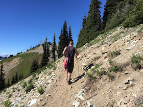
Wil picking his way down the trail:


Back on to public land, 2.8 miles to go...


This was a long hike -- we were hiking for over 5 hours in total. I managed to turn an ankle pretty badly on the loose rock, but we moved along pretty quickly. We did see a lot of people heading up on our way down, and were amused that a lot of them were part of a large Chinese hiking group.

Back at the trailhead there were a lot of cars, but still some parking spaces. This wasn't necessarily a hike I would do again; but it was a good training hike. 

Mount Washington
8.7 miles
3333 ft elevation gain


Tuesday, July 17, 2018

Hike of ... a while ago : Crystal Mountain Summit House


A couple of weeks ago we needed to do a 2.5 - 3 hour hike... but wanted to go somewhere new, and get some elevation gain under our boots... so a one-way hike up to the Crystal Mountain Summit House seemed like a perfect fit. Okay, so our hike was only 2 hours long, but it was all uphill! 

The ski area's website said that as of the week prior, there was still enough snow on some trails that hikers weren't sure where the trail went. So we played it safe and took Kelley's Gap Road to the Green Valley Trail. 


We started off from the large, almost empty parking lot a little before 8am. We would be going up. 


The road wasn't very scenic, but every so often would open up to a nice view to show how quickly we were ascending.


Up and up we went, mostly in the sunshine.


It's always a little disconcerting to not be able to see where you're aiming for, but we just kept going up. 


Nope, still can't see the "summit".


We crossed a small creek -- lovely and cool and refreshing.


Then across that scree field, very dusty...


And, always, up.


The wildflowers were in bloom, too; I didn't take a lot of photos but liked that there are at least 6 different flowers visible in this shot.


Eventually we reached the top of Kelley's Gap Road, and joined a likely "Green Valley Trail". There were actually a few small trails here, so we just picked one and -- though we did make one turn onto a larger track -- it turned out to be the correct trail.


Green Valley was, indeed, green.


Even if we did wonder how people ski between all those trees...


We continued up -- noting our first glance, in the distance, of the Summit House.


And, eventually, the first peeping glance of Mount Rainier's summit. By the way, yeah, the trail was pretty rocky here!


 It's also possible, obviously, to take the gondola up and hike down; but where the fun in that?


We arrived at the "top" and had it pretty much to ourselves for a little while.


We also saw the trail marker for the top end of the Crystal Mountain trail, which I'd like to hike up some other time.


And even though we didn't see or hear any elk, we saw some evidence...


Seriously, what a gorgeous day!


 We sat down in the chairs near the restaurant and soon had some company. Little beggar.


I could look at this picture ALL DAY. 


Eventually, the restaurant opened we got a perfect table at the edge of the patio.


Beers + small plate of fries = our reward!


But it was getting oddly crowded at the top -- crowds of folks coming up the gondola, each carrying a trekking pole they had borrowed for their "hike"... So after finishing up we got our "download" tickets (half price for just going downhill, just like at the Grouse Grind) and then rode down.


I'd like to do this hike again -- well, a different trail up -- and I think we'll add this to our "places to take visitors in the summer" because it's so freakin' glorious. 

#bootie

Crystal Mountain Summit via Kelley's Gap Road and the Green Valley Trail
3.4 miles
2444 ft elevation gain